Learn how to check the current traffic in the Apple Maps app on your iPhone, iPad, or Mac to avoid congestions, road closures, and construction work, saving time.
How to show and recognize traffic conditions in Apple Maps
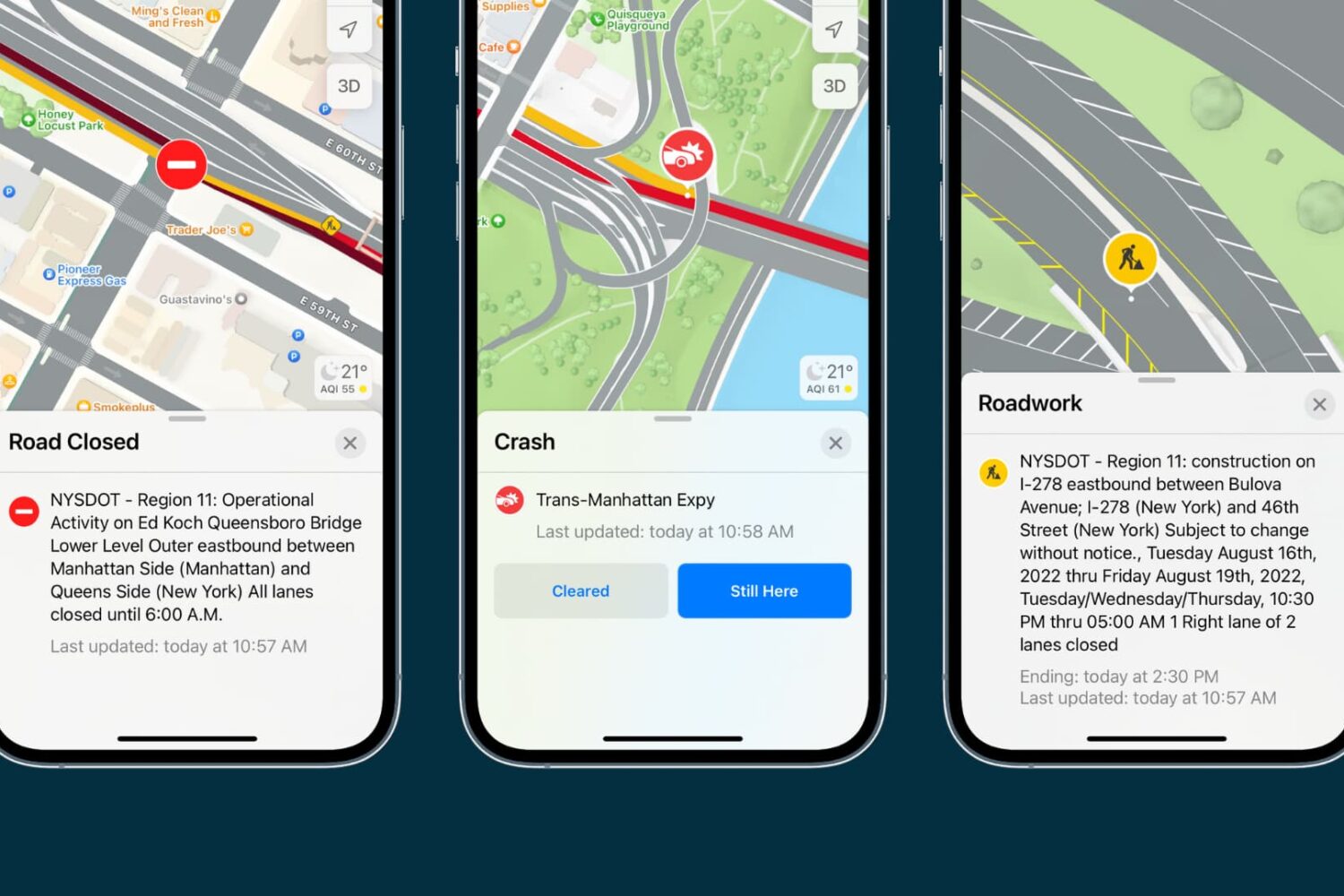
Learn how to check the current traffic in the Apple Maps app on your iPhone, iPad, or Mac to avoid congestions, road closures, and construction work, saving time.
In a renewed vote of confidence in Apple's smartwatch, the popular Transit app is back on the Cupertino company's wearable platform. It also brings with it a few new features such as expanded trip information that now includes wheelchair accessibility information.
Real-time traffic information in Apple's Maps app is now available in six new countries around the globe, according to the company's Feature Availablity page. As first discovered by MacRumors, the new countries include Brunei, Kenya, Mozambique, Philippines, Nigeria, and Vietnam.
Apple Maps now provides real-time traffic conditions to customers in Argentina, according to Apple's refreshed iOS Feature Availability webpage.
Apple Maps will now denote highly congested areas with orange or red lines along the roads, helping drivers avoid any delays. With today's update, real-time traffic conditions are now available in a total of four Latin American countries via Apple Maps: Argentina, Brazil, Chile and Mexico.
Real-time updates about vehicular traffic on Apple Maps have expanded to include Greece, home to population of eleven million people, according to an update posted on Apple’s iOS Feature Availability webpage. The latest expansion comes hot on the heels of launching public transit directions on Maps in Prague earlier in the week.
Traffic data on Apple Maps is currently available in about three dozen countries, including the United States, the United Kingdom, Canada, China, Singapore, Australia, New Zealand, Mexico, South Africa, Spain, Belgium, Germany, France, Italy, Netherlands, Czech Republic, Denmark and more.
Flyover, a three-dimensional birds-eye view in Apple Maps, is now available in an additional thirty cities and popular tourist destinations in the United States and around the world. In addition, Transit and Traffic data in Maps is now available in several new cities.
Flyover takes advantage of a fleet of airplanes that photograph points of interest from multiple angles. These photos are then used to derive depth information from them to recreate buildings, landmarks and other objects in 3D space.
A steady stream of regular Apple Maps backend updates continues unabated with the latest expansion of the Nearby and Flyover features in new cities and countries around the world. In addition to five new major cities in Germany, Japan and the United Kingdom that now support Maps' three-dimensional Flyover views, the Nearby feature is now available in Austria, Denmark, Japan and Switzerland to help Apple's customers there find local businesses and points of interest relative to their current location.
Google-owned social-mapping and traffic service Waze today pushed an update to its iPhone application in the App Store, adding handy shortcuts available upon pressing its Home screen icon on the iPhone 6s and iPhone 6s Plus.
Waze's 3D Touch shortcuts provide access to popular features like address search, location sharing and turn-by-turn navigation based on your work and home address on file.
Waze, a crowdsourced GPS, maps and traffic service owned by Google, has refreshed its iPhone and iPad application with a few new features.
Now available at no cost in the App Store, the new Waze 3.9.4 is much faster than before. More importantly, it has added a cool new feature which tells you how long you'll be stuck in a traffic jam.
Other features like navigation, route select and re-routing have been sped up significantly, an important feat given that you'll be using the app while driving.
Waze, a popular crowdsourced GPS, maps and traffic service, announced on Wednesday that it's rolling out AMBER alerts in the United States.
Realized through a partnership with the National Center for Missing and Exploited Children, the move brings AMBER alerts to Waze users when a child in their area has been abducted or gone missing.
Putting its June acquisition of the popular social mapping and location startup Waze to good use, the Internet giant Google today announced that crowd-sourced incident reports from Wazers will be soon available through the Google Maps mobile apps for iOS and Android.
This means when Wazers report accidents, construction, road closures and more on Waze, their updates will also appear in real-time on the Google Maps mobile apps in Argentina, Brazil, Chile, Colombia, Ecuador, France, Germany, Mexico, Panama, Peru, Switzerland, UK and the US...
In addition to sourcing maps data in iOS 6 from fifteen different companies, Apple also allows traffic routing apps from third-parties to lend their services to the entire system by way of new APIs.
And since Apple's Maps app knows about routing apps in the App Store, it'll give users a choice to download them when needed. This is making good on Apple's promise that it will partner with third-party developers on Maps transit directions "where it makes sense"...