Maps

Here’s all-new Google Earth crashing on iPad during yesterday’s presser

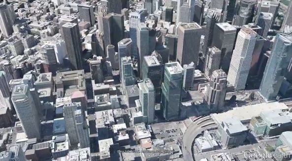
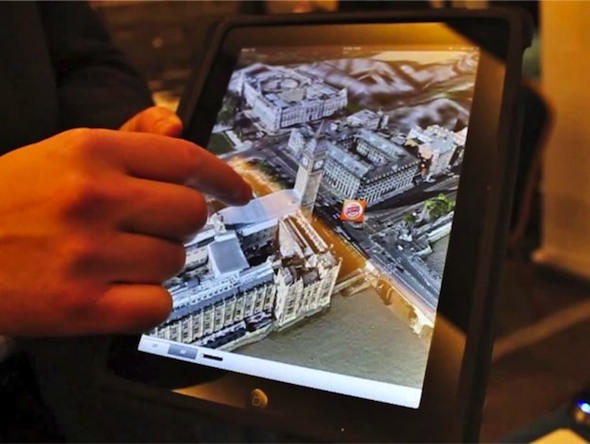
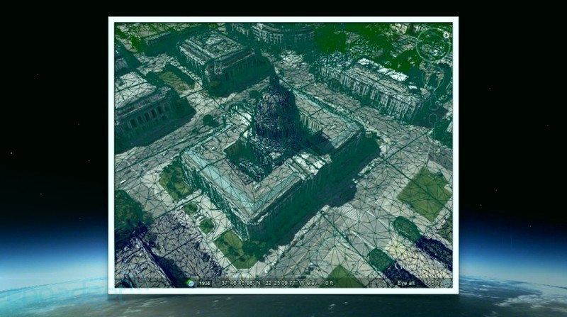
Our friend and former iDB writer Alex Heath points us to a short clip highlighting Google's embarrassment at yesterday's hastily organized press conference to announce "the next dimension in Maps". Instead, as pointed out by MG Siegler, the search Goliath revealed anxiety over Apple Maps.

Be that as it may, the fact remains that Google put up a pretty boring show, rushing out a new version of Google Maps and looking foolish in the process...

Check out Google’s clip showing off gorgeous 3D cityscapes in Google Earth

As we noted in our liveblog, today's Google Maps presser has brought out the much-anticipated 3D imagery that we're being told is coming to both Android and iOS platforms via the Google Earth mobile app.

And as Apple reportedly gears up to preview its own 3D mapping solution at WWDC next Monday, it's time to take a closer look at what Google's technology can do.

Well, the search giant just posted an awesome video that shows off 3D cityscapes, complete with buildings, terrain and even landscaping, from the new 45-degree aerial imagery in Google Earth. It's pretty awesome and I for sure am liking a lot where they're taking maps (apparently, I'm not the only one)...

Apple to preview in-house Maps at WWDC, ousting Google Maps later this year

The usually well-informed Wall Street Journal is throwing its weight behind rumors that Apple with iOS 6 will ditch a Google Maps backend and instead pursue own in-house mapping solution. Sources tell the paper that although Apple could, and probably will, show off the enhanced Maps app at WWDC next Monday, the feature won't launch until later this year.

This should give developers a much-needed head start to incorporate Apple's mapping technology into their apps and take advantage of the reportedly unique features. The story offers other interesting tidbits, including the new calendar-integrated mapping system...

Mockup depicts enhanced Maps on four-inch iPhone 5

As you know, iOS 6 will bring an all-new Maps app said to feature Apple's own tiles and brand new in-house solution for breathtaking 3D view.

Though Google is expected to add the third dimension to its own Maps service as early as Wednesday, we've already seen screenshot mockups depicting 3D terrain in iOS 6 Maps.

As for the enhanced two-dimensional view, here's what the new Maps app could look like on that next iPhone that by all accounts seems to feature a taller four-inch display...

Google teases “the next dimension” of maps, should Apple be worried?

Not content with being outclassed by Apple, Google today sent out invitations to select members of the press. The invite graphics teases "the next dimension of Google Maps". The search giant's presser takes place next Wednesday, June 6, at 9:30am, five days ahead of Apple's worldwide developers conference that kicks off with a keynote in San Francisco's Moscone West on June 11.

Looks like both tech titans are keen on taking the maps experience to the next level, which can only be a good thing for us consumers and market watchers. But As Apple debuts its own in-house mapping solution, market dynamics will inevitably change due to Apple's size, brand power and for the simple fact that Cupertino will no longer be paying fees for using Google's tiles in Mac and iOS applications and services.

Of course, it's also the question of pride...

Purported screenies show off enhanced iOS 6 Maps with breathtaking 3D view

Remember talk of Apple's enhanced Maps app thought to feature cutting-edge 3D view?

Apparently a few years in the making, looks like Cupertino is now ready to supplant a Google Maps backend with its own in-house mapping solution come June 11.

And now, screenshots from a "trusted source" have surfaced, depicting this exciting three-dimensional mapping view in action. The admittedly gorgeous photos look authentic and conceivably show off the power of a declassified missile targeting technology Apple got hold of with their 2011 acquisition of advanced 3D mapping startup C3 Technologies...

AllThingsD confirms Apple will use its own mapping system in iOS 6

Earlier this morning, 9to5Mac reported that the next major release of iOS, expected to debut at WWDC next month, will include a completely redesigned Maps application. The report explained that this would be one of iOS 6's major new features.

While the site certainly has some credibility in the world of Apple rumors, it's always nice to get some corroboration from other sources. And we've just received that, from AllThingsD's Apple guru John Packzkowski...

iOS 6 said to replace Google Maps with Apple’s own cutting-edge 3D Maps

If a new rumor is to be believed, iOS 6 - the next major release of Apple's iOS operating system powering the iPhone, iPod touch and iPad - will forgo Google Maps in favor of Apple's in-house mapping service based on incredible 3D maps. The headline new feature will still be called Maps.

However, this is where all similarities reportedly end. The iPhone maker is rumored to innovate Google-backed maps in iOS with an awesome 3D technology based on a declassified missile targeting technology. This in-house solution is said to offer "a much cleaner, faster and more reliable experience". More importantly, Apple's own mapping service will reduce their dependency on Google.

Moving from a Google Maps backend to an Apple backend is also important given that the two companies have been at odds ever since the search Goliath decided to challenge the iPhone with its Android platform...

Request anyone’s location, regardless of device, with Space-time for iOS

TheNextWeb points to an interesting new application called Space-time. The software allows you to see the location of almost anyone, regardless of their device, as long as they have a smartphone with a GPS locator.

Of course, the iPhone already has a friend-tracking solution in Find My Friends. But it only works if you are trying to locate a person using an iOS device with the app installed. Space-time is much more universal...

OpenStreetMap admits it’s behind iPhoto for iOS mapping service

Yesterday we reported that Apple's new iPhoto app for iOS is using the company's own internal mapping solution instead of Google's. This was a big deal because Apple has used Google Maps in nearly everything for the last 5 years.

Well it looks like we got it partially right. The maps used in iPhoto's geotagging service isn't Google Maps. But it isn't Apple's either. As it turns out, the data is coming from an open-source mapping company called OpenStreetMap...

New iPhoto app doesn’t use Google Maps

Earlier today, Apple unveiled a new iPhoto application for iOS during its iPad 3 event. The app is essentially a mobile version of its popular photo editing and management software for the Mac.

While we've already outlined most of iPhoto's components, a new discovery has been made regarding one of its features. It appears that the app doesn't use Google Maps for any of its GPS-related tasks...