Apple Maps

Use Apple Maps and plan trips on the big screen with TV Maps for Apple TV

Since learning that Apple's software development kit now includes a new MapKit framework for tvOS, I've been eagerly awaiting to see what Apple TV developers are going to do with it. I salivated at the prospect of Apple Maps on a big screen telly because it sounded too good to be true.

Even better, Apple's SDK supports advanced features like map annotations, adding overlays and performing reverse-geocoding lookups to determine placemark information for map coordinates, among other features.

With TV Maps by Arno Appenzeller—to my knowledge, this is one of the first of MapsKit-enabled apps for the new Apple TV—you can browse Apple Maps from the comfort of your couch. At long last, planning trips on the big screen has become a reality for those of us who're invested into the Apple ecosystem. The experience of using maps on a television is much cooler than you could imagine: this is the first tvOS app that has made me wish that the Apple TV supported hand gestures so that I could explore maps Minority Report-style.
Apple Maps web app may be in the works

Latest checks indicate that Apple is getting ready to make the Maps service available to everyone on the web through a desktop web application which will permit you to embed an Apple Maps view into your own webpage, blog and more.

Look no further than Apple's own WWDC 2016 webpage, which appears to take advantage of what seems to be an interactive, embedded Maps view. This is the first time Apple has used an embeddable Maps view on the web.

Apple Maps gains Transit data for Seattle

After adding transit data last week for public transportation in Portland, Oregon and Montreal, the second-largest city in Canada, Apple on Monday brought Apple Maps' Transit feature to Seattle in Washington.

First spotted by MacRumors, the most recent Transit expansion lets Apple's customers in the city incorporate public transportation options like the Link Light Rail, Monorail, buses and more into Maps when seeking turn-by-turn directions.

Apple Maps Transit data now available in Montreal and Portland, Oregon

Over the past few days, Apple's expanded availability of Transit data on its mapping service to include Portland, Oregon and Montreal, the second-largest city in Canada. Just a month ago, Transit data was added for Austin, Texas, in time for the annual South by Southwest festival.

It also brought 3D Flyover views to five new locales in Germany, Japan and the United Kingdom and expanded the Nearby feature to select new places in Austria, Denmark, Japan and Switzerland.

Apple Maps brings Nearby, Flyover and Traffic features to more countries and locations

A steady stream of regular Apple Maps backend updates continues unabated with the latest expansion of the Nearby and Flyover features in new cities and countries around the world. In addition to five new major cities in Germany, Japan and the United Kingdom that now support Maps' three-dimensional Flyover views, the Nearby feature is now available in Austria, Denmark, Japan and Switzerland to help Apple's customers there find local businesses and points of interest relative to their current location.

watchOS 2.2 launches with Nearby in Maps, pairing of multiple watches and more

In addition to the major iOS 9.3 software update for the iPhone, iPod touch and iPad, a companion software update for the Apple Watch released this morning, too. The new watchOS 2.2 firmware is now available as an over-the-air download in the companion Watch app for the iPhone.

watchOS 2.2 is not as major a release as iOS 9.3 or OS X 10.11.4 so ti includes only a few improvements such as the Nearby feature in Apple's Maps app, the ability to pair multiple watches to a single iPhone and more.

Apple Maps adds 23 new Flyover locations

Apple continues to expand availability of the Flyover feature in its mapping service with today's backend update having enabled a total of 23 new landmark locations all over the world where three-dimensional Flyover view is available.

Select new cities in the United States, the United Kingdom, Australia, Belgium, Canada, France, Italy, Mexico, Spain and Taiwan have gained support for Flyover, such as Spain's A Coruña, Australia's Newcastle, England's Nottingham and more.

Apple is opening a development office in India’s Hyderabad to support Maps development

The 1.25 billion people market of India is estimated to soon become the world's top smartphone market and is already one of Apple's most important markets despite the fact that the Cupertino firm is yet to open its first branded store in the country.

But that's not stopping Apple from investing in India. According to a statement Tuesday by an Apple spokesperson given to The Economic Times, the iPhone maker is opening a new $25 million development office in Hyderabad, where some 150 employees will be supporting Maps development.”

Get where you’re going with fewer steps using these 3D Touch shortcuts in Apple Maps

Getting where you’re going with fewer steps is a lot easier with time-saving 3D Touch shortcuts in Apple Maps. For example, pressing the Maps icon on the Home screen lets you instantly get directions home, send your location to a friend, search what’s nearby or drop a pin on your current location so you can remember where you parked your car.

And within the Maps app, 3D-touching a point of interest lets you preview it quickly, navigate there, call the place and more.

In this tutorial, you're going to learn about all the ways you can take advantage of 3D Touch shortcuts that are currently supported in Apple Maps.

Apple boosts Maps with new Flyover cities, Traffic and Nearby data

Apple has updated its Maps backend with nearly two-dozen new cities now supporting the Flyover feature. In addition, the company has activated live Traffic data for Taiwan and added Finland to the list of countries that support iOS 9's Nearby feature. Three-dimensional Flyover data has been added to five new cities in the United States, with additional Flyover views now available in various cities across Europe, Africa and Japan.

Apple adds Pittsburgh, Detroit and other new Flyover locations to Maps

Apple on Wednesday added 11 new locations to the 3D Flyover feature in its iOS and OS X Maps applications. The new spots include major cities such as Detroit, Pamplona and Pittsburgh.

First introduced when Apple Maps launched in 2012, the Flyover feature allows users to take interactive, three-demensional virtual tours of various points of interest from around the world.

Boston transit data and Amtrak routes for Northeastern U.S. launch on Apple Maps

In addition to bringing Yellow Pages-powered business listings to Apple Maps customers in Canada, the Cupertino firm has apparently refreshed a Maps backend in the United States, adding transit directions for Boston and multiple Amtrak routes in the Northeastern United States.

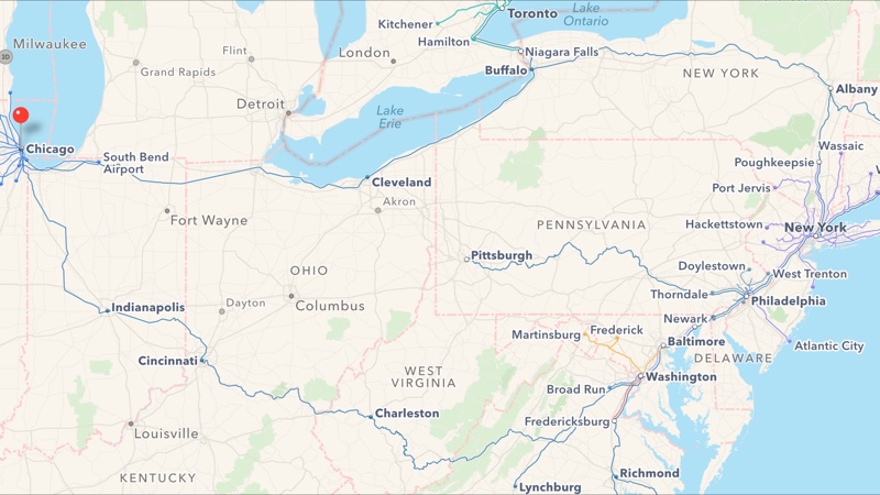
The longest Amtrak route available runs from Chicago to New York. As first noted by MacRumors, other supported routes with transit directions include the Northeast Regional, Acela Express, Keystone, Lake Shore Limited, Pennsylvanian and Maple Leaf.