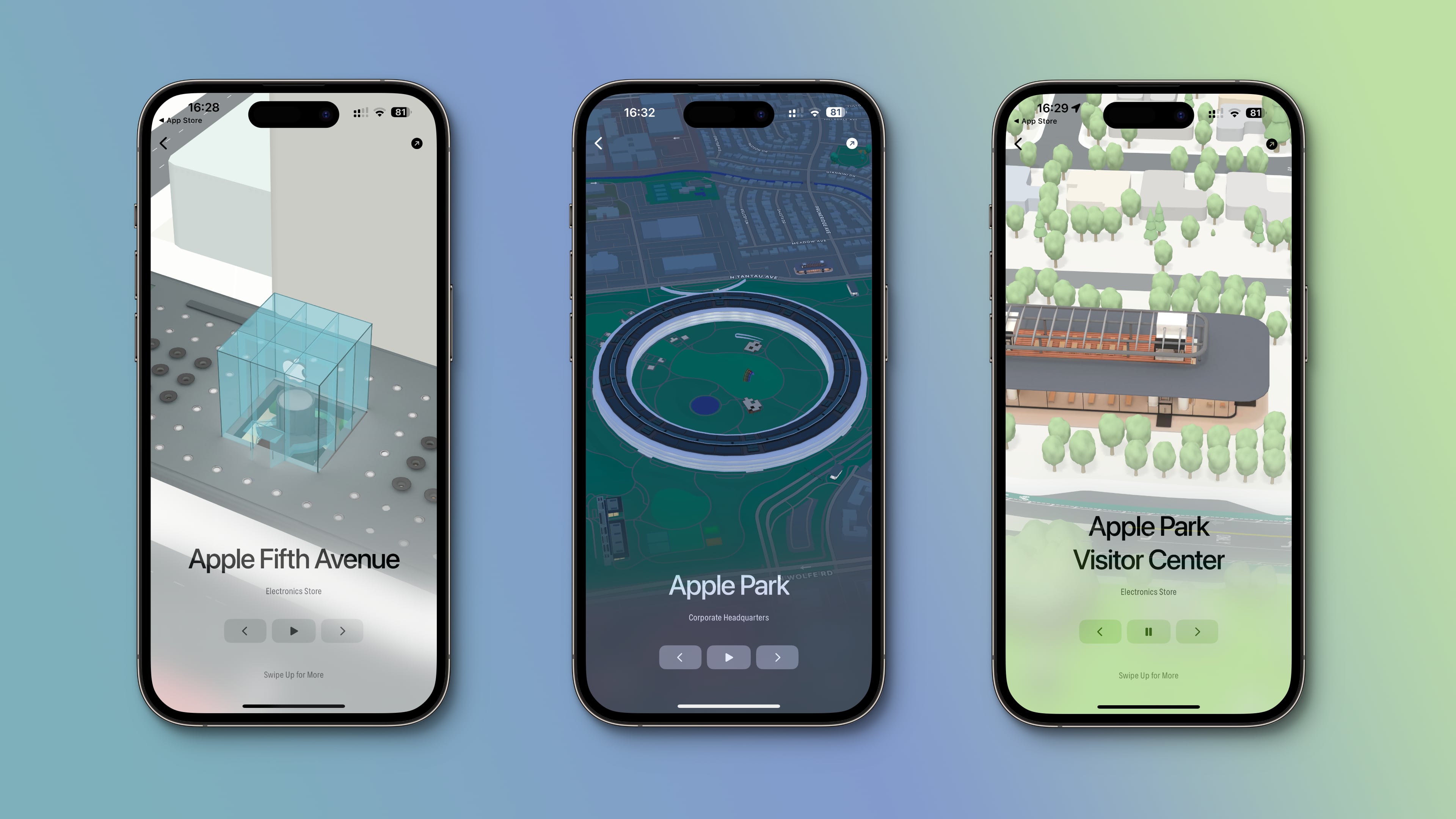
The Landmarks app lets you explore a curated collection of more than 300 custom-designed 3D models that are available on Apple Maps, organized by city.
iOS 15 brought a new Detailed City Experience feature with immersive three-dimensional views of landmarks in major cities like Boston’s Fenway Park, London’s Royal Opera House, San Francisco’s Golden Gate Bridge or Sydney’s Opera House.
Apple only lists the cities where 3D landmarks are available (but you need to visit a webpage for that), not the actual landmarks. Wouldn’t it be great if someone wrote an app highlighting all 3D landmarks available on Apple Maps?
Explore all Apple Maps 3D models with the Landmarks app
That’s what Montréal-based developers André Baev and Simon Gardinier had in mind when they set out to create their new app, dubbed Landmarks.
It lets you explore 3D models from Apple Maps, neatly organized by city and regularly updated with new models as they become available. Just select a city for a list of all its landmarks, then choose one to interact with. This is way better than manually exploring whole cities in Apple Maps in search of potential 3D landmarks.
Light and Dark mode
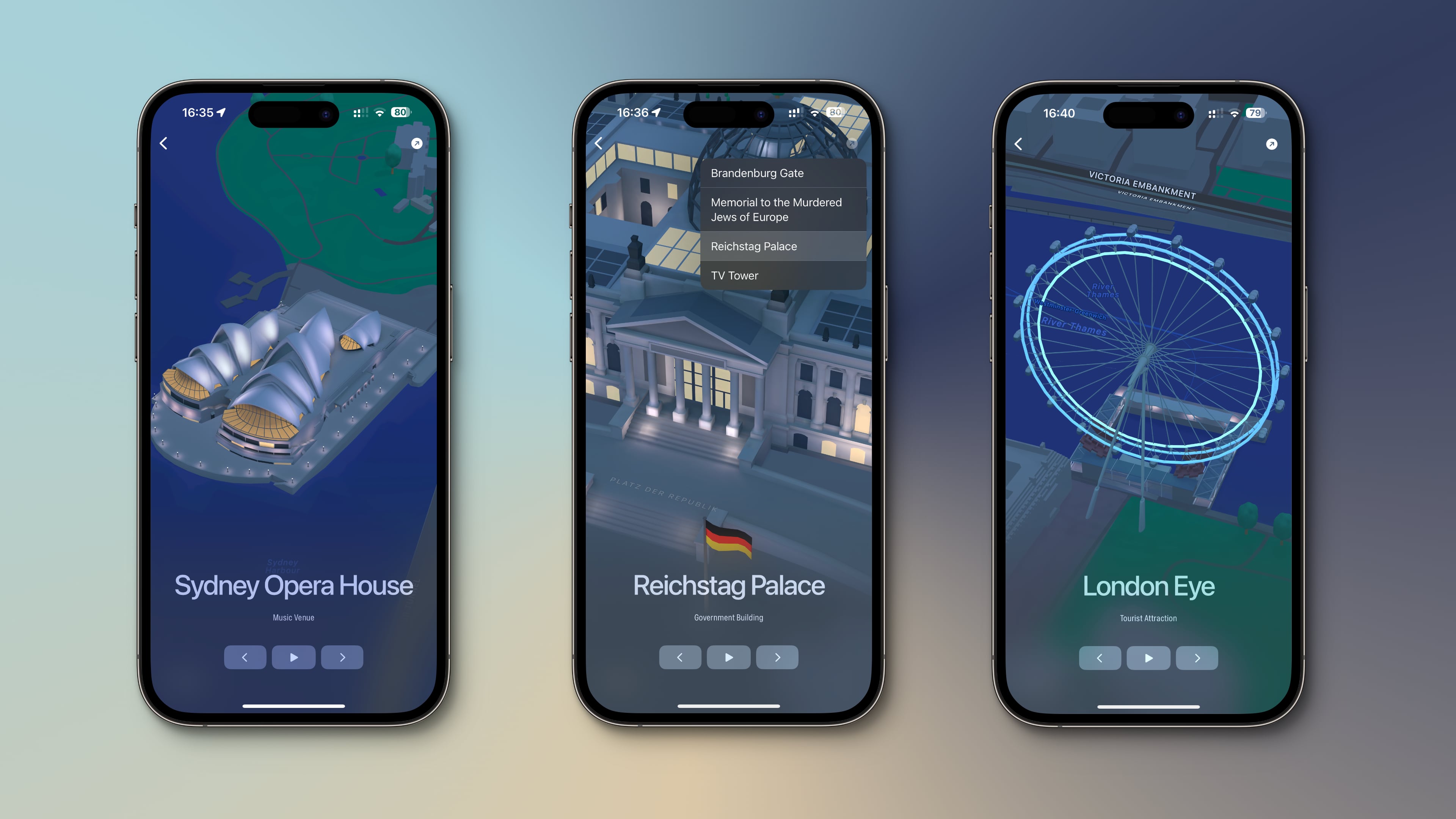
These highly detailed 3D models look great, but that’s only half the story. Each 3D model can be viewed in Light or Dark mode and is surrounded by an immersive landscape.Thankfully, you can pause the animation to appreciate painstakingly modeled details and resume it right where you left off.
You can rotate the map, pan around and zoom in/out using the Apple Maps gestures. The app will also suggest landmarks and sync your favorites across devices.
On macOS, you can run Landmarks in fullscreen mode to make the most out of every pixel, but you’ll need an Apple silicon computer to fully appreciate detailed graphics.
The app effectively addresses a need for more discoverability in Apple Maps. I especially appreciated the option to quickly open any 3D model in the Maps app. The Landmarks app uses the Apple Maps API so it can offer all these features.
Where are Detailed City Experiences available?
According to Apple’s iOS and iPadOS Feature Availability webpage, the Detailed City Experience feature with custom-designed 3D models is currently available in nearly three dozen cities, including Atlanta, Chicago, Las Vegas, Los Angeles, Miami, Boston, New York, Philadelphia, San Diego, San Francisco and Washington.
Apple brought its redesigned Maps experience to Boston (where I’m from!) today, and the level of detail is insane 🤯 pic.twitter.com/zklXftXi4G
— Frank McShan (@frankmcshan) March 16, 2023
In addition, Detaile City Experiences are also available in non-US cities such as London, Melbourne, Sydney, Montréal, Toronto and Vancouver. Apple refreshes this list from time to time to account for new 3D landmarks added to the Maps app.
Pricing and availability
The Landmark app is available for the iPhone, iPad, Mac and Apple TV. The software is free to download and doesn’t serve ads. Landmarks offers in-app purchases for those who wish to support developers and unlock the gyroscope feature.
The app requires macOS 13.0 or later and iOS, iPadOS and tvOS 16.0 or later. Developers recommend using an iPhone or iPad with at least an A12 chip or an Apple silicon Mac powered by an M1 chip or later to fully enjoy detailed graphics.