Apple is currently beta-testing the first major update to iOS 10 since its public release last month. Aside from a Portrait shooting mode for iPhone 7 Plus owners and a new toggle in Settings to allow Messages animations when Reduce Motion is enabled, the software update should bring official support for transit directions in Japan within the stock Maps application, Japanese blog Ata Distance said today.
Maps
Google Maps gains redesigned iOS 10 widgets for “Nearby Transit” and “Travel Times”
Google yesterday bumped its mapping application for the iPhone, iPad and iPod touch to version 4.23, adding a few new features including revamped widgets for “Nearby Transit” and “Travel Times” that now adhere to iOS 10's new design style for widgets.
In Google Maps 4.23 for iOS, you can now upload photos along with your reviews of places and see descriptions of places including features, atmosphere and amenities.
Apple to unify its separate cloud services teams to improve Siri, Maps, iTunes, iCloud & more
Bloomberg's Mark Gurman is reporting today that Apple is in the process of unifying its separate cloud services team in an effort to foster tighter collaboration between them, better compete with Google and Amazon in the cloud space and improve Siri, Maps, iTunes, iCloud and other services.
Eddy Cue, Apple's boss of Internet Software and Services, will oversee the effort to move cloud service engineering teams to a single campus as Apple continues shifting its cloud to its own infrastructure.
How to avoid toll roads in Apple Maps for one or all journeys
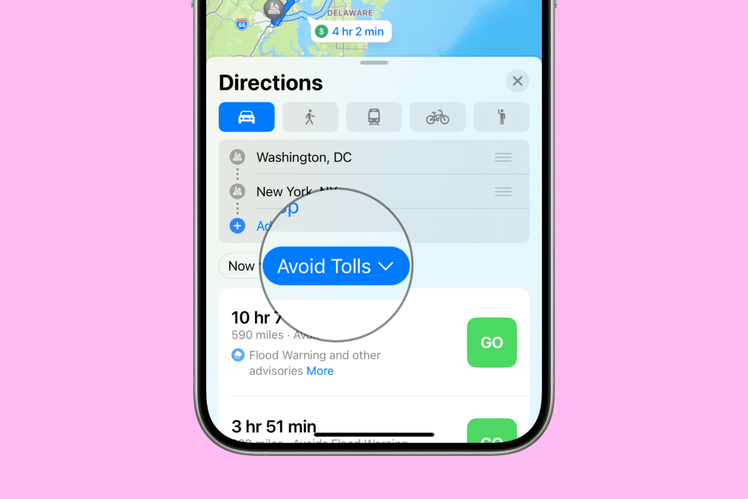
Want to avoid toll roads in Apple Maps on your iPhone, iPad, or Mac? In this tutorial, we’ll share two different methods to do that.
Go Radar update adds better Pokémon scanner and improvements to zoom

Ever since the removal of the footsteps feature from Pokémon GO, the crowdsource-based Go Radar app from the App Store has quickly become one of the most popular ways to help with Pokémon tracking.
The latest update (version 2.0) brings Pokémon scanning functionality that users have been requesting for some time, as well as improvements to the app's workflow that helps users get more out of it.
LocationHandle lets you spoof your location on iOS 9.3.3 [jailbreak]
Your location is an important piece of information, and sometimes apps ask for it. If you're somewhat of a privacy monger, then you might like to keep a lot of apps from acquiring your true location and logging information about you.
With a new jailbreak tweak called LocationHandle, you can actually spoof your location. This tweak works on iOS 9.3.3, unlike many other popular location-spoofing jailbreak tweaks, and we'll show you how it works in this review.
Go Radar tracks Pokémon locations in real time
Pokémon GO is all the hype right now, and lots of people are enjoying playing it, but there is a substantially high number of people who are upset with the removal of the Footsteps feature in the game, and even more-so game developer Niantic's decision to start shutting down real-time Pokémon trackers.
If you're having trouble finding the Pokémon you want after the update that removed Footsteps, you might consider trying a crowdsourced Pokémon tracker app instead of one that relies on Niantic's servers to feed information.
Apple Maps launches Traffic data in Greece
Real-time updates about vehicular traffic on Apple Maps have expanded to include Greece, home to population of eleven million people, according to an update posted on Apple’s iOS Feature Availability webpage. The latest expansion comes hot on the heels of launching public transit directions on Maps in Prague earlier in the week.
Traffic data on Apple Maps is currently available in about three dozen countries, including the United States, the United Kingdom, Canada, China, Singapore, Australia, New Zealand, Mexico, South Africa, Spain, Belgium, Germany, France, Italy, Netherlands, Czech Republic, Denmark and more.
Google Maps for iOS refreshed with cleaner look, now highlights local areas of interest
Google today updated its mobile mapping application for the iPhone, iPad and iPod touch with some rather useful visual tweaks. Google Maps 4.21 for iOS now highlights local areas that might interest you, adding multiple destinations to a route is supported in the new version and the typography of street names, points of interest, transit stations and other places has been improved to make them easier to read on smaller screens, among other changes.
Apple Maps Transit data expands to San Diego, British Columbia, Honolulu and Kansas City
Transit directions on Apple Maps are now available in four new markets: San Diego, Honolulu and Kansas City in the United States and British Columbia, Canada’s westernmost province. Now Apple fans can incorporate localized public transportation options in those locations, including buses and commuter rails, when seeking directions through the Maps app.
Trouble finding good Pokémon with Pokémon GO? Try this

Pokémon GO took the mobile device community by storm, and already, it has launched in several countries.
The game, which allows you to capture Pokémon in what’s known as a virtual reality experience, gets players up and moving to find random spawns of Pokémon throughout their town or city.
But not everyone is having the best of luck finding the Pokémon they want, so in came a slew of apps to help out...
Apple Maps expands Flyover coverage, adds Traffic/Transit data for multiple locales
Flyover, a three-dimensional birds-eye view in Apple Maps, is now available in an additional thirty cities and popular tourist destinations in the United States and around the world. In addition, Transit and Traffic data in Maps is now available in several new cities.
Flyover takes advantage of a fleet of airplanes that photograph points of interest from multiple angles. These photos are then used to derive depth information from them to recreate buildings, landmarks and other objects in 3D space.