
Following Monday’s announcement that Maps will gain Transit directions and other new features when iOS 9 launches this fall, some folks are reporting that the feature actually works in even more cities than Apple has said, as discovered by MacRumors.
Not only that but navigating with Maps provides en route traffic and construction warnings, including voice turn-by-turn suggestions for alternate routes, according to information shared with AppleInsider.
As shown below, an AppleInsider reader said Siri on his iPhone running the iOS 9 beta provided a spoken warning that there was “heavy traffic ahead” while suggesting a specific exit to avoid the congestion ahead.
In addition, Siri warned him about ”roadwork ahead, with no traffic” while driving in Cleveland. These spoken warnings were accompanied by on-screen banners showing where the work is taking place and how far away it is.
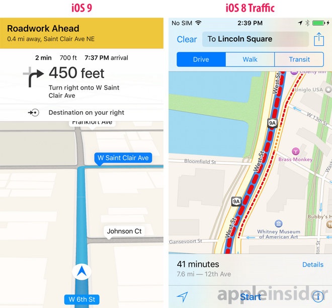
“The iOS 8 version of Maps does incorporate traffic data, including alternate routes and details on the causes of backups, but the information is limited to route creation and estimating arrival times,” noted the publication.
Meanwhile, MacRumors has discovered that transit directions in Maps actually work across much of the Greater Toronto Area and Southern Ontario, as evidenced by this screenshot showing Apple Maps providing transit directions in Waterloo and Barrie.

The publication has confirmed that bus, subway, light rail and train directions are available between over a dozen Canadian cities, including Mississauga, Oakville, Brampton, the York region, the city of Hamilton, Burlington, Kitchener-Waterloo-Cambridge, Guelph and the Niagara region.
In addition, Apple Maps supports GO Transit and bus service in Barrie, Pickering, Ajax, Whitby, Oshawa, Peterborough and Milton. According to Apple’s refreshed Apple Maps transit acknowledgments webpage, the following third-party Transit operators in Canada are supported in Apple Maps:
- GO Transit (Buses & Trains)
- Toronto Transit Commission (TTC)
- MiWay — Mississauga
- Oakville Transit
- Brampton Transit
- York Region Transit (YRT)
- Viva Rapid Transit — York Region
- Hamilton Street Railway (HSR)
- Burlington Transit
- Grand River Transit (GRT) — Kitchener-Waterloo-Cambridge
- Guelph Transit
- Niagara Falls Transit and Niagara Region Transit
- St. Catharines Transit
- Welland Transit
- Niagara Region Transit
- WEGO — Niagara Falls
The iPhone maker said transit directions will initially roll out to Baltimore, Chicago, New York, San Francisco, Philadelphia, Mexico City and Washington, DC in the United States; Berlin in Germany; London in the United Kingdom; and Toronto in Canada when iOS 9 and OS X El Capitan launch this fall.
As shown further below, a new Transit view in Maps lets you tap metropolitan transit system with schedules, subway station entrances and exits and ferry lines precisely mapped. You can plan a route using public transportation and Maps will offer a combination of trains, subways, buses and walking, or ask Siri for transit directions.

Another improvement in iOS 9 Maps: a new Nearby feature showing you points of interest relative to your current geographical location, with the ability to search for food, drinks, shopping, fun and more.
You can also explore additional sections within each category. For example, under Food you’ll see Popular, Restaurants, Groceries, Fast Food, Cafés, Bakeries and Desserts.
Lastly, Apple’s confirmed that its minivans are cruising around the world in order to collect data to improve the service, with some of this data to be published “in future Apple Maps updates.“
Source: MacRumors, AppleInsider