If there’s one thing we all learned from Apple’s Maps mea culpa, it’s that mapping the globe is a tricky business. It took the search giant seven years and tremendous manpower to turn Google Maps into the world’s most popular mapping service. Quick to exploit rivals’ weaknesses, Google once more outlined its mapping advantage today just as Tim Cook’s apology was making rounds on the web…
The company announced in a post over at the official Google LatLong blog the addition of 45-degree imagery for 37 major cities in the United States, in addition to fourteen international locations.
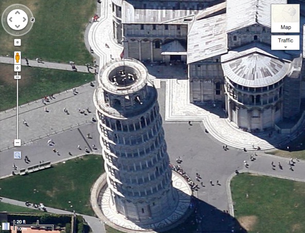
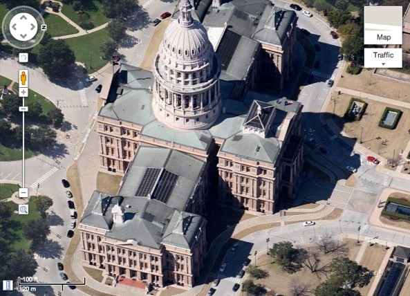
These high-resolution images vastly improve the experience. Though it ain’t true 3D view like Apple’s Flyover view, the 45-degree perspective looks really nice and you can zoom in to get astounding detail as Google’s bitmaps are in very high-resolution.
45-degree view of Texas State Capitol in Austin, Texas
Some examples worth checking out: the Leaning Tower of Pisa and Citadel of Lille in France, The Forks in Winnipeg in Canada and Texas State Capitol in Austin, Texas.
To enjoy these new crisp imagery, zoom in on using the “+” sign located right below the orange person icon. To change your perspective, drag ring in the upper left corner.
Google also perfected aerial imagery for seventeen cities added brand new satellite imagery for 112 countries and regions.
Here’s the full list of cities with high-res satellite and 45-degree imagery.
Cities with new high resolution 45° imagery:
United States: Ames, IA; Anderson, IN; Billings, MT; Bloomington, IL; Carmel Valley, CA; Cedar Rapids, IA; Coeur d’Alene, ID; Corvallis, OR; Danville, IL; Dayton, OH; Detroit, MI; Dubuque, IA; Elizabethtown, KY; Enid, OK; Florence, SC; Grand Forks, ND; Great Falls, MT; Gulfport, MS; Hartford, CT; Kankakee, IL; Kenosha, WI; Lafayette, IN; Lancaster, CA; Lansing, MI; Lewiston, ID; Los Banos, CA; Madison, WI; Medford, OR; Michigan City, IN; Olympia, WA; Pocatello, ID; Sheboygan, WI; Sioux City, IA; Sioux Falls, SD; South Bend, IN; Terre Haute, IN; Utica, NY.
International: Angers, France; Clermont-Ferrand, France; Coimbra, Portugal; Dijon, France; Grenoble, France; Livorno, Italy; Lyon, France; Newcastle, United Kingdom; Oberhausen, Germany; Palermo, Italy; Pisa, Italy; Toulouse, France; Troyes, France; Winnipeg, Canada.
Areas with new high resolution aerial updates:
Florence OR, Kellogg ID, Casper WY, North Platte NE, Concordia KS, Alva OK, Austin TX, Nevada MO, Chilicothe MO, Toulouse FR, Clermont-Ferrand FR, Angers FR, Nantes FR, Troyes FR, Lille FR, Thun CH, Lucca IT
Areas with new high resolution satellite updates:
Canada, United States, Mexico, Cuba, Jamaica, Haiti, Dominican Republic, Guatemala, Honduras, Nicaragua, Costa Rica, Panama, Colombia, Venezuela, Brazil, Peru, Bolivia, Paraguay, Uruguay, Argentina, Antarctica, South Africa, Namibia, Botswana, Mozambique, Zimbabwe, Madagascar, Zambia, Angola, Malawi, Tanzania, Democratic Republic of the Congo, Kenya, Somalia, Ethiopia, South Sudan, Sudan, Uganda, Central African Republic, Nigeria, Cameroon, Chad, Niger, Benin, Ghana, Burkina Faso, Ivory Coast, Guinea, Sierra Leone, Mali, The Gambia, Senegal, Mauritania, Western Sahara, Morocco, Algeria, Tunisia, Libya, Egypt, Israel, Saudi Arabia, Yemen, Oman, Qatar, United Arab Emirates, Kuwait, Turkey, Iran, Ireland, Norway, Sweden, Portugal, Spain, France, Italy, Poland, Lithuania, Finland, Belarus, Ukraine, Moldova, Romania, Hungary, Austria, Croatia, Serbia, Bulgaria, Greece, Russia, Kazakhstan, Uzebekistan, Turkmenistan, China, Pakistan, India, Sri Lanka, Bangladesh, Thailand, Nepal, Bhutan, Myanmar, Laos, Vietnam, Korea, Japan, Mongolia, The Philippines, Malaysia, Indonesia, Australia, New Zealand.
I like these 45-degree shots a lot.
Apple’s Flyover view is also awesome, but it’s in 3D and lacks the polish of Google’s high-resolution 45-degree imagery. It kills me that Apple bothered flying airplanes to create Flyovers, but wouldn’t introduce its own detailed aerial photos of key landmarks.
Is your area now available in high-res glory?
My country is listed under “Areas with new high resolution satellite updates”.

