Giving credit where credit is due, Apple now properly acknowledgeds use of crowd-sourced map tiles from OpenStreetMap for its $4.99 iPhoto photo management program for the iPhone and iPad.
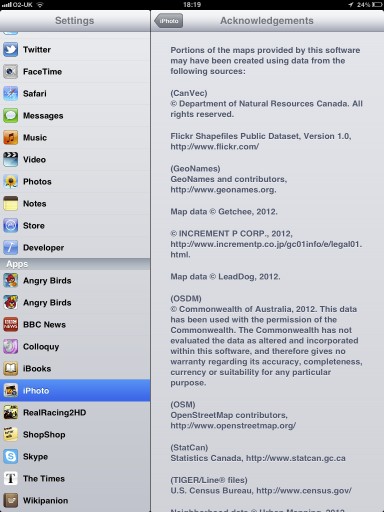
The proper attribution has been discovered in yesterday’s iPhoto 1.0.1 maintenance update, tucked away in legal text found under the Apps section in device Settings.
With that off our backs, we wonder when will Apple make an iOS-wide switch from the Google Maps backend to its own mapping solution…
As first discovered by The Next Web‘s Matt Brian, Apple now directly credits OpenStreetMap contributors and even provides a link back to their site.
It’s been discovered back in March that Apple began using its own map tiles in iPhoto for iOS, made from OpenStreetMap data (outside the United States).
iPhoto taps map tiles to superimpose your images over the world map, letting you see where you snapped them.
OpenStreetMap welcomed Apple with a March blog post, updating it yesterday with this note:
Apple appear to have added OpenStreetMap attribution in their iPhoto v 1.0.1. We’re delighted to see another prominent map user make the switch to OpenStreetMap, and look forward to many more.
And here’s your screenshot.
Most users didn’t even notice the change, though bloggers were quick to note that map tiles in Photo for iOS are now less detailed than they used to be in prior versions that had used Google’s backend.
The change came following informal contacts the OSM Foundation made with staff at Apple regarding proper attribution.
OpenStreetMap on its part says Apple is using rather old database from April 2010, “so don’t expect to see your latest and greatest updates on there”.
It’s interesting that both Forusquare and Wikipedia made a switch from Google Maps to OpenStreetMaps in their mobile apps.
OpenStreetMap, as the name suggests, is the open-source mapping service which taps crowd-sourced data and allows for edits similarly to Wikipedia.
Apple has long-been rumored to be working on a mapping solution of its own in order to reduce its dependency on Google data in iOS. Another reason: Google recently said it would charge high-volume users for access to its Maps APIs.
Apple’s own mapping solution is said to be cutting-edge and believed to stem from three recent acquisitions: Placebase maps service in 2009, followed by Poly9 in 2010 and C3 Technologies in 2011.
Now, venture-back C3 Technologies is a mind-blowing 3D mapping company, a spin-off of the aerospace and defense company Saab AB.
Here, have a look at Saab’s awesome rapid 3D mapping tech.
[tube]CNemPTHOKWg[/tube]
In 2009, Apple dropped Google and Skyhook Wireless data in iOS 3.2 to tap its own location database.
The company also made waves last spring, saying it was “collecting anonymous traffic data to build a crowd-sourced traffic database” to provide iPhone users with an “improved traffic service in the next couple of years”.
We should know more about Apple’s mapping plans at the company’s annual developer conference, which runs this year from June 11-15 in San Francisco’s Moscone West, where iOS 6 is very much likely to be the main topic of conversation.
So, is Apple’s switch to an alternate mapping data provider a sign of things to come?

